Recording Methodology
SRS Phase 2 broad habitats, structural vegetation layers, collecting methods or detail and MapMate
In phase 2 of the Spider Recording Scheme we are beginning to obtain considerable quantities of detailed data on our British spiders in a standardised computerised format. Since these data are potentially extremely valuable in providing us with considerable quantities of information about the detailed ecology of species, both generally and in different parts of the country and at different times of year, it seems very important to try and obtain consistent data. You can record our phase 2 data on the updated RA65v2 recording cards, or best of all directly into MapMate, using "Araneae: Spider Recording Scheme" as a filter included in "My configuration".Recording consistent data
When validating card data against BRC computer entries and when entering data from new RA65 forms into the the SRS database there have been a numbers of cases where site descriptions did not match up at all with the broad habitats that had been completed by the surveyor. Using the Ordnance Survey on-line map service to check the grid references against the OS map often indicated that there seems to be confusion about the use the broad habitat, with some recorders thinking about the broad habitat at too much of a fine scale. To this end the following text attempts to clarify the use of broad and structural habitats in the scheme. There will be cases where choices will be difficult, or even impossible, and in these cases the recorder should either make what they see as clearly the best choice or should leave it not recorded - there are definitely cases where it is better to have no data than data that would confuse. No habitat classification can ever be wholly satisfactory and there remain many problems with the one we are currently using, some of which we hope to address. It is always possible, and desirable, to record extra information as additional comment if felt useful.Broad habitats
The broad habitat is the basic overall habitat in which you have collected the spiders and to complete this you need to think at a larger scale than your immediate collecting area, e.g. in a mixed woodland you should include grassy paths, rides or clear felled areas as part of the mixed woodland, not as grassland. On the other hand a large grassland field between two woodland blocks should be classified as the relevant grassland broad habitat. Collecting off coniferous trees in a mixed woodland should not be classified as coniferous woodland, unless you can create a sizeable sub-site or compartment within the woodland that is wholly made up of coniferous trees. Collecting off coniferous trees in a mixed woodland is a matter of detail, and something that needs to be recorded in the comment field. A single tree or small number of trees do not in themselves constitute woodland or a woodland category.The SRS is encouraging the use of MapMate biological recording and mapping software, for various reasons, but in particular for its ease of exchange of data over the internet, the software's ability to automatically keep track of records subsequently edited, added or deleted, the up to date checklists used and excellent support provided. In MapMate broad habitats, sub-habitats and associated substrate, hydrology and management features are site based, so that new sites need to be set up for each combination of these. This is not as time consuming or difficult as it seems, since it only has to be done once for any site/sub site. Good ways of naming these have been set out, e.g. by Ian Dawson in his article on MapMate in SRS News 46 (July 2003). As long as your basic locality name is consistent, then you can create as many sub sites as you like without affecting the ease with which the data can be searched. Even if you are submitting records by recording cards, it is useful to realise that sites will be used in this way.
The broad habitats are a combination of the original phase 1 RA65 habitats with additional phase 2 habitats, to allow continuity in the data. This means the habitats in use are far from ideal, but at least they allow continuity with phase 1 data and provide a structured framework for recording. Currently the broad habitats and sub habitats consist of the following:
| Broad habitat | No |
|---|---|
| Arable | 35 |
| Buildings, indoors | 14 |
| Cave, tunnel, well or culvert | 16 |
| Cultivated land, including gardens | 13 |
| Gardens, parks | 36 |
| Gorse | 07 |
| Grassland, acid | 31 |
| Grassland, calcareous | 11 |
| Grassland, improved | 32 |
| Grassland, neutral | 30 |
| Grassland, other | 12 |
| Heath/moor, heather | 05 |
| Heath/moor, other | 06 |
| Machair | 04 |
| Not Recorded | 0 |
| Other | 23 |
| Post-industrial, buildings/industrial infrastructure | 34 |
| Post-industrial, mineral extraction sites/spoil heaps | 33 |
| Rock, scree, cliff or quarry | 15 |
| Saltmarsh | 02 |
| Sand dune | 03 |
| Scrub | 17 |
| Shingle | 01 |
| Wasteground | 22 |
| Wetland vegetation, acid | 09 |
| Wetland vegetation, other | 10 |
| Wetland, acid bog | 24 |
| Wetland, carr/swamp | 26 |
| Wetland, edges of lakes, ponds, rivers and streams | 29 |
| Wetland, fen | 25 |
| Wetland, marsh | 27 |
| Wetland, open water | 08 |
| Wetland, reedbed | 28 |
| Woodland, conifer | 19 |
| Woodland, deciduous | 18 |
| Woodland, mixed | 20 |
| Woodland, young conifer plantation | 21 |
| Subhabitat | No |
|---|---|
| Not Recorded | 0 |
| Ditch | 1 |
| Verge | 2 |
| Hedgerow | 3 |
| Gorse scrub | 4 |
| Scrub (other) | 5 |
| Scattered Trees | 6 |
Evident management features for a site or sub site are:
| Management | No |
|---|---|
| Not Recorded | 0 |
| 1. Unmanaged | 1 |
| 2. Grazed | 2 |
| 3. Cut | 3 |
| 4. Coppiced | 4 |
| 5. Clear-felled | 5 |
| 6. Burning | 6 |
| 7. Physical disturbance | 7 |
Hence for example a clear-felled area within a woodland would be classified as a broad woodland habitat and then as "5. Clear-felled". Since clear-felled areas will be replanted or left to regrow, in a number of years time the habitat of this same area will have changed. To allow for this in MapMate the site name could be along the lines of e.g. "Blakes Wood (clear-felled area)", so that if someone records the same place in 40 years time when it has returned to mature woodland, records from exactly the same area can still be related to the habitats present at the time of collection rather than just the grid reference.
Habitat detail, method (MapMate Method) and structural vegetation layers (MapMate Status)
When looking through MapMate records sent in by recorders there is sometimes an obvious mismatch between the collecting method and the structural vegetation layer that has been selected.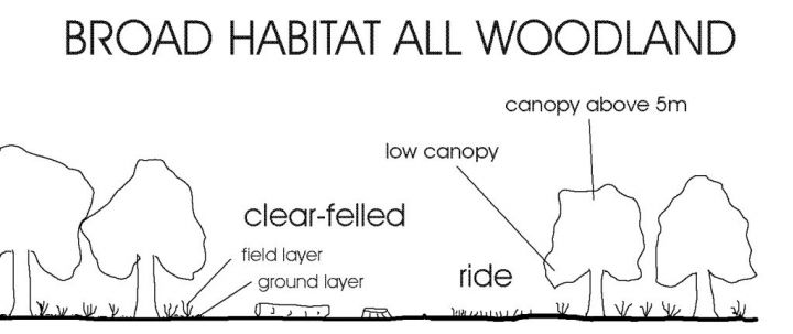
Nothing about ecology is ever simple, and the phase 2 structural classification (in MapMate the Status field when using "Araneae: Spider Recording Scheme" in your configuration) was an attempt to record more detailed information of where spiders are found by using a system based on the vegetation layers in woodland. In a simplified form these can be seen as the ground layer, the field layer, the understory or shrub layer and the canopy. Non-woodland habitats can be seen in a similar way, but without the canopy.
Unlike with broad habitats this time we should be thinking on a small scale, the actual area around you when you are collecting or have set traps.
The structural habitat recorded should always refer to where a spider is found, not to the surrounding vegetation. For example, spiders collected by grubbing on the ground or at the bases of plants would be classified as in the ground layer regardless of the surrounding vegetation.
The field layer refers to herbaceous vegetation . Spiders collected by sweeping are normally from the field layer which generally is <20cm or >20cm and <1-1.5m in height.
Shrub and low canopy refers to woody species, i.e. scrub or shrub species and low branches of trees, which are most easily sampled by beating - even if they are sampled by sweeping actions they are still considered as shrub or low canopy. Hence bramble would count as being in this layer unless it is prostrate or not woody. To try and take some account of the vegetation cover (e.g. a good proportion of spiders appear to always be found in areas of sparsely vegetated habitat or small areas of bare ground, or always in tall dense vegetation etc) we subdivided these. You can use the general category where it is not feasible or sensible to subdivide. The MapMate "Method" field also allows you to record either your collecting method or detail about where in a habitat the spider was found (these had to be combined in order to be incorporated into the MapMate record entry). Whilst it is possible to create new Methods in MapMate, you must remember that if you do this, these will not then be within the SRS classification and will not be available for analyses. Creating new Methods is therefore NOT recommended.
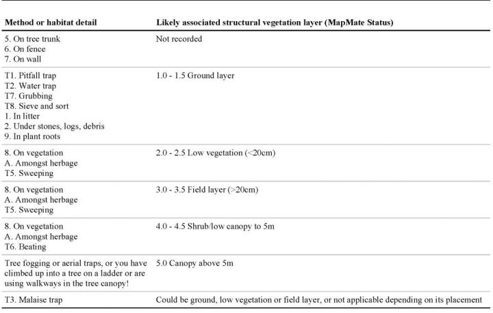
Several habitat details are included because they provide microhabitats commonly used by various spiders, such as "On tree trunk", "On fence", "On wall", "In aerial litter, birds nests etc". However these particular microhabitats cannot satisfactorily be associated with structural vegetation layers - e.g. on a tree trunk is not the same as the structural canopy layer that can be beaten to find spiders, so in cases like this the Status field should be left "Not recorded".
There has occasionally been some confusion over the meaning of the term "grubbing". "Grubbing" refers to the time honoured technique used by arachnologists and other ground dwelling invertebrate specialists, where the field worker can be found on their hands and knees, backside in the air, using their hands to sort amongst the roots and ground layer of plants and litter. It therefore has a pretty close association with the ground layer (of course even this is not always easy to know for certain e.g. if you are grubbing amongst tall vegetation, you may disturb spiders that then drop un-noticed to the ground, where you then find them - nothing is perfect!).
Of course these are not fixed associations, since it is possible to employ aerial pitfall or pan traps, and beating can be employed on tall herbaceous vegetation as well as scrub or canopy.
Analyses of these kinds of data can provide us with valuable information about whereabouts in a broad habitat different spiders are usually found, and also by looking at these data throughout the year and by longitude and latitude we can learn whether species move into different structural habitats during the year or behave differently in different parts of the country. Many field workers will already know that these things happen, but the availability of these data will enable us to quantify what happens and apply statistics to find out whether the data provide significant results.
| Habitat detail and Method | No |
|---|---|
| 0. Not Recorded | 1 |
| 1. In litter | 2 |
| 2. Under stones, logs, debris | 3 |
| 3. Under bark | 4 |
| 4. In aerial litter, birds nests etc | 5 |
| 5. On tree trunk | 6 |
| 6. On fence | 7 |
| 7. On wall | 8 |
| 8. On vegetation | 9 |
| 9. In plant roots | 10 |
| A. Amongst herbage | 11 |
| T1. Pitfall trap | 12 |
| T2. Water trap | 13 |
| T3. Malaise trap | 14 |
| T4. Vacuum sampling | 15 |
| T5. Sweeping | 16 |
| T6. Beating | 17 |
| T7. Grubbing | 18 |
| T8. Sieve and sort | 19 |
| active searching | 20 |
| Field record / observation | 21 |
It is easy to accidentally record methods which do not match the structural habitat (MapMate Status field using the SRS phase 2 categories), and these will then be displayed in the charts in the Species Summary on this website. Therefore MapMate users please check your records against the table below, edit them where necessary and then resync to your Area Organiser and then to the National Organiser, so that the SRS Phase 2 data on this website is as accurate as possible.
An example of the use which can be made of these data is given in the species summary or Structural habitat by month page
There are at least 32 fields of information in the MapMate SRS Phase 2 structure, with several of these effectively hidden from the user (such as BRC number). Whilst this all might seem too time consuming and tiresome to record, quite a few fields are associated with a site, so only have to be completed once for any site or sub-site. In addition where a casual fieldwork visit is made to a site it may well not be possible to complete the fields relating to management, substrate etc - if in doubt don't complete. Structural habitat features are related to each separate species record, but if you keep all the spiders from one structural habitat separate from those collected from another structural habitat (e.g. you keep those collected by grubbing in one tube of alcohol, those swept in another tube and those beaten into another tube and so on) then it is not difficult to enter these quickly into MapMate from your lists of identifications by locking the fields that remain the same and entering only the taxon and quantity/sex for all those species recorded from the same Status and by the same Method.
No habitat classification is ever going to be satisfactory or accommodate for all circumstances. The NVC system is not only beyond many naturalists (if for no other reason than the price of the volumes) but is also not particularly relevant from an invertebrate point of view, where spiders for example are rarely bothered by the plants present other than from a structural point of view. We may want to update the current classification in a way that can reasonably easily accommodate existing data. In particular there is the problem over how to allow broad habitats within habitats or habitat systems to be recorded, e.g. large areas of grasslands within woodlands, dune systems supporting pine plantations, calcareous grasslands, marshes, fens and so on, as well as the dunes themselves. Any ideas and opinions from members of the BAS are very welcome.
Habitat-Site associations and how to define site names in Mapmate
Validation of data computerised by BRC from RA65 cards in autumn 2005 raised a number of issues about lack of consistency in the use of site names generated by paper data, and inconsistencies between site descriptions and broad habitats. The import of these and various other Excel data into MapMate raised an important question over how to deal with site names in MapMate, so that broad habitat information is not lost, and unilateral decisions had to be made over site names and associated habitats in order to make the data consistent with the overall aims of the recording scheme.In MapMate every site consists of a unique site name-grid reference combination. SRS broad habitats and other SRS site-related information (SRS Site Details) are uniquely related to each site, whereas numbers, sex of specimens, structural habitat, collecting methods, etc are associated with individual species records. Many parent sites will contain a number of different broad habitats, and hence it will be necessary to set up a sub site for each SRS Site Detail combination. This is not as onerous as it might seem, since it only has to be done once for any one sub site. However it becomes essential to ensure that sites and sub sites are named in a way that clarifies the broad habitat that is associated with it, so that confusion does not arise when it is used, both by the creator of the site name, but also perhaps by other MapMate users.
The means to do this has already been explained extremely well in Ian Dawson's article "MapMate and the Spider Recording Scheme" (July 2003 SRS News 46: 12-14).
The purpose of the current article is to remind MapMate users of its importance and the value in using a standardised method to assign site and sub site names. Hopefully it will also be useful for non-MapMate recorders to be aware of the implications their site names might have when their records are imported into MapMate, since these will have to be adapted to ensure that site name-SRS broad habitat/SRS Site Detail combinations are unique.
The recommended method to use when naming sites is MainSite, SubSite: Compartment followed by a descriptive identifier for the SRS broad habitat/SRS Site Detail in parentheses, so that you and other users can identify the habitat associated with a particular site name. Hence examples of sites named in this way might be as follows:
- Savernake Forest, Grey Road (decid)
- Savernake Forest, Braydon Oak (mixed)
- Savernake Forest, Birch Copse (conifer)
- Savernake Forest, Cp 12 (clear felled)
Or
- East Head (saltmarsh)
- East Head (shingle)
- East Head, West (fore dune)
- East Head, Northwest (fixed dune)
- East Head, Central (dune slack)
- East Head (scrub)
This method can also be used to differentiate areas of land where management changes take place and associated changes in species are being monitored:
- Bellrope Meadow (ungrazed)
- Bellrope Meadow (grazed)
- Savernake Forest, Cp 12 (prior to clear fell)
- Savernake Forest, Cp 12 (clear felled, 1 year re-growth)
- Savernake Forest, Cp 12 (clear felled, 2 year re-growth)
- Savernake Forest, Cp 12 (clear felled, 3 year re-growth)
The whole site name is limited to 64 characters. Although sites are also identified by their grid reference, unless any associated habitat is identified in the name you or another MapMate user would be able to use the site name without easily realising that the habitat associated with it might not be applicable to the records you are about to enter (although this can be checked in the data entry window by clicking on Site and selecting from the drop down list Show all related > Site Details).